
Ghana is facing a double-edged climate risk in 2026: counting the cost of catastrophic floods while bracing for possible drought within the same rainy season.
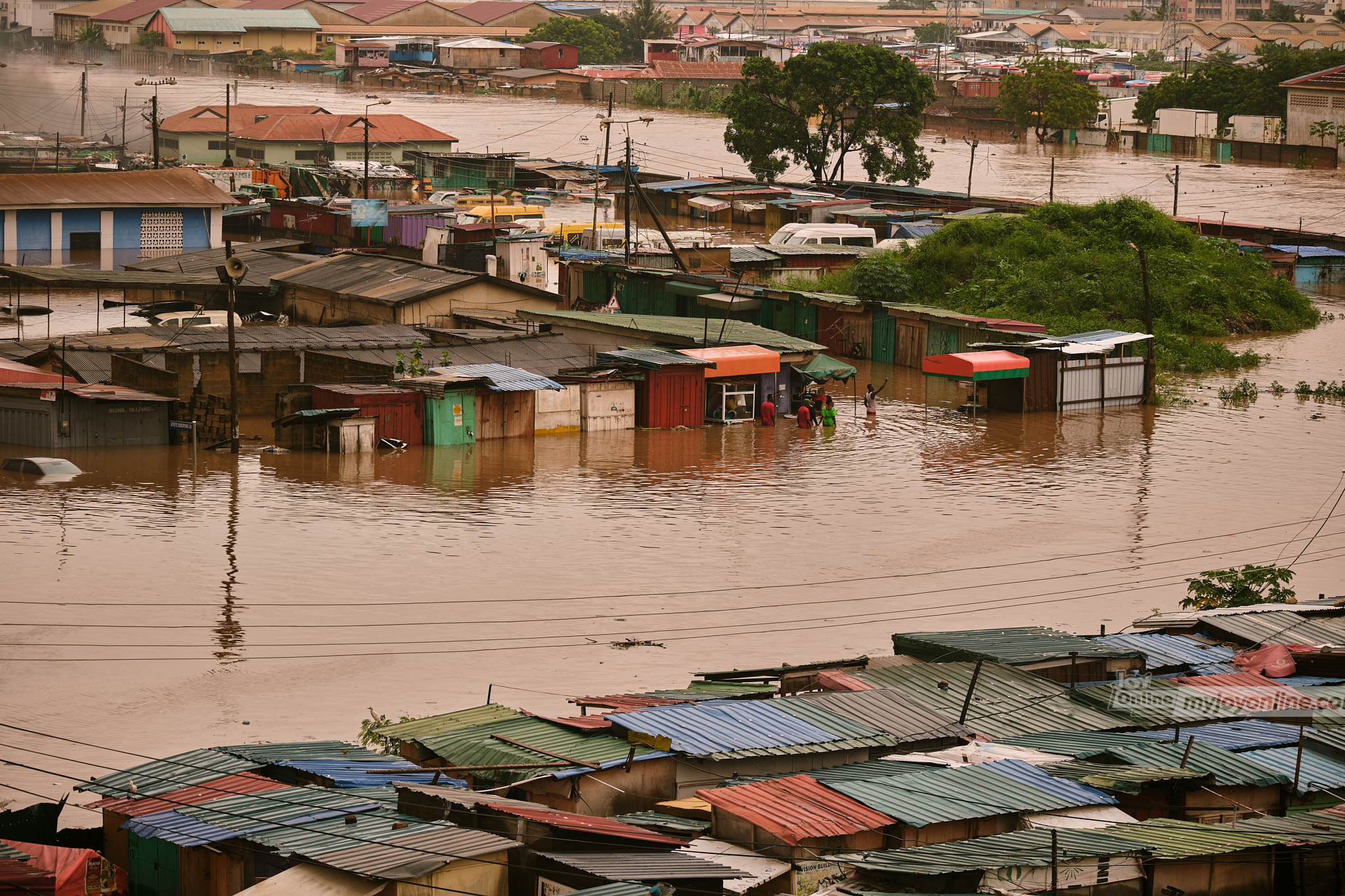
Barely a month ago, Ghana was reeling from devastating floods. On June 28–29, 2026, a violent rainstorm triggered flash floods across Greater Accra and parts of southern Ghana. Neighbourhoods including Spintex, Adabraka, Achimota, and Agbogbloshie went underwater, major arteries like the N1 were impassable, and homes, vehicles, and businesses were destroyed.
Cape Coast, Kumasi and other cities in southern Ghana have also experienced flooding during this year’s rainy season.
These floods have left dozens dead across the cities. Damage assessments put losses in the hundreds of millions of dollars, which is expected to increase once indirect costs to trade and small businesses are included; the government released GH¢300 million from its Contingency Fund for immediate response.
It may seem paradoxical, but that same climate system now points toward the opposite hazard of dry spells and drought for the rest of the year. The intense rains of late June were consistent with a normal rainfall expected during the peak of the main rainy season in southern Ghana. For the rest of the year, Ghana will be dealing with a strengthening El Niño that historically tilts the odds toward below-normal rainfall and early-ending rains later in the season.
Earlier this year, we published this article showing that after nearly two years dominated by La Niña and neutral conditions, the tropical Pacific was tilting toward an El Niño event for late 2026 into 2027. At the time, the signal was still probabilistic. A cluster of international climate models was converging on a common signal for an El Niño event but the timing and eventual strength of the event remained uncertain. That caution has now given way to confirmation.
In its Global Seasonal Climate Update, the World Meteorological Organization (WMO) confirmed that El Niño conditions have developed in the tropical Pacific and are strengthening rapidly, with a strong El Niño event projected for July–September 2026. Multi-model ensembles from leading forecasting centres show a consistent and pronounced warming of sea-surface temperatures across the central and eastern equatorial Pacific, with seasonal anomalies expected to exceed 2°C in key monitoring regions. The WMO first flagged the transition in June, giving an 80% probability of El Niño emerging between June and August 2026, rising to around 90% thereafter. NOAA’s Climate Prediction Center went further, assigning a 63% chance the event reaches very strong intensity by November 2026–January 2027 (see Figure 1). The projected conditions are comparable to the historic 1997/98 and 2015/16 Super El Niños.
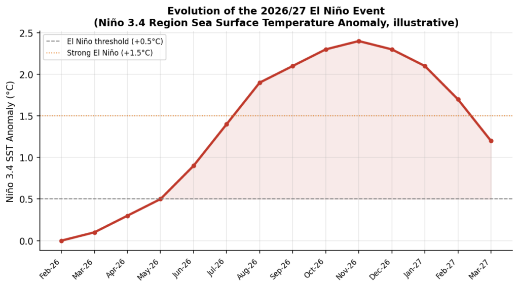
Figure 1: Illustrative evolution of the Niño 3.4 sea-surface temperature anomaly through the 2026/27 event, based on WMO and NOAA CPC seasonal outlooks. Values are indicative of the forecast trajectory, not official real-time readings.
El Niño is the warm phase of the El Niño–Southern Oscillation (ENSO), a natural, irregular cycle (roughly every two to seven years) driven by fluctuations in sea-surface temperature and atmospheric pressure across the tropical Pacific. During an El Niño event, the eastern and central Pacific warms well above average, weakening the trade winds that normally push warm surface water westward. This reorganises the pattern of rising and sinking air across the tropics, and changes rainfall patterns across the globe.
Because the atmosphere is a single connected system, this Pacific disturbance has knock-on effects. These knock-on effects are referred to as teleconnections and have impacts on global rainfall and temperature patterns to varying degrees. Typically, El Niño brings wetter conditions to parts of South America, the southern United States, and East Africa. In Australia, Indonesia, southern Africa, and much of West Africa’s Gulf of Guinea coast, El Niño leads to drier conditions (see Figure 2). It also tends to raise global average temperatures, since the extra ocean heat adds to the atmosphere’s existing warming trend. This pattern has contributed to prior strong events becoming some of the hottest years on record.
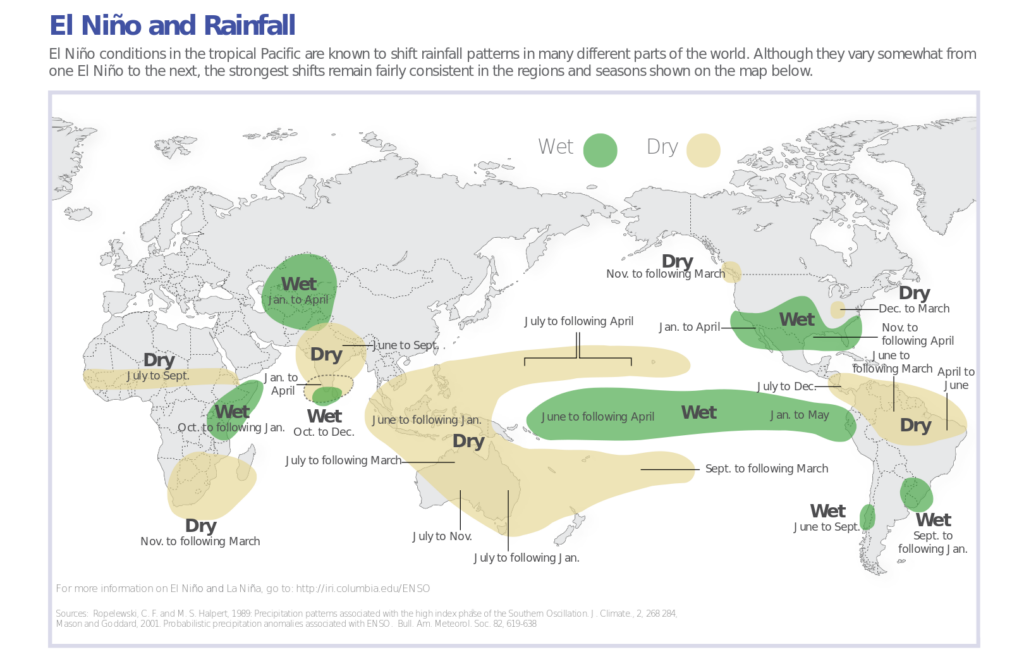
Figure 2: Schematic diagram of El Nino impacts on global rainfall showing areas which get wetter (green) and dryer (orange) as a result of the impact of El Nino events.
Ghana’s rainfall is not immune to these Pacific-driven shifts, and the country’s climate record carries the scars of its three most significant El Niño events.
The 1982/83 El Niño produced what remains Ghana’s most severe modern drought. Rainfall reduced across the country, and the resulting dry spell combined with widespread bushfires to destroy thousands of hectares of cocoa farms, damage food crops, and trigger localised famine. Station data from the period show the deficit was not simply low annual totals.
Similarly, in 1997/98, there was another El Niño event, one of the strongest on record globally. This event similarly disrupted West African rainfall patterns, contributing to below-normal totals across parts of the Guinea Coast and reinforcing the region’s vulnerability to Pacific-driven dry spells.
The 2015/16 event, comparable in strength to 1997/98, again brought drought stress to Ghana and Côte d’Ivoire, the world’s two largest cocoa producers. Regional studies identify 2015/16, alongside 1982/83, as among the most severe drought periods recorded across Ghana’s cocoa agroforestry belt in the past four decades, with reduced rainfall and elevated temperatures pushing crop water stress to unusually high levels.
Across all three episodes, the common thread is a weakened or shortened rainy season, disproportionately affecting the second half of the growing calendar — precisely when crops are most sensitive to moisture stress.
Regional guidance issued in mid-2026 points to a similar, though not identical, pattern for the 2026/2027 El Niño event. Seasonal outlooks from AGRHYMET’s Regional Climate Centre and the WMO Coordination Mechanism, discussed at a June 2026 briefing for UN agencies and humanitarian partners, indicate a pronounced east–west contrast in rainfall probabilities across equatorial Africa, with below-normal rainfall favoured across large parts of the Sahel and mixed signals across the Gulf of Guinea.
For Ghana specifically, the most consistent risk signal points to below-normal rainfall during the minor rainy season (roughly September–November) in southern Ghana, the period historically most sensitive to El Niño’s influence on the West African monsoon. In the north, where the rains follow a single unimodal season running from around May to October, forecasts point toward an earlier-than-normal cessation of rainfall, shortening the effective growing window (see Figure 3). Should this pattern hold, a weak minor season in the south combined with a truncated main season in the north raises a real risk of localised dry spells in the coming months.
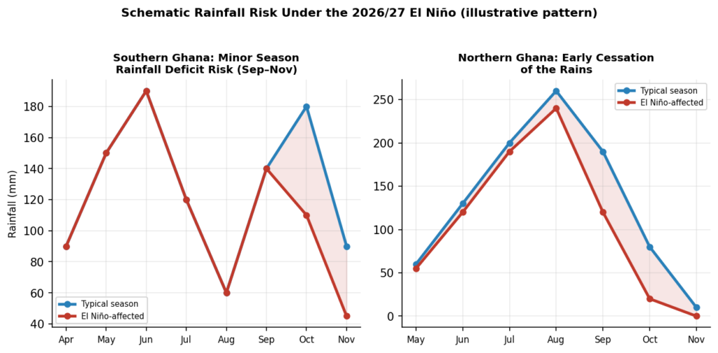
Figure 3: Illustration of the rainfall risk pattern associated with the 2026/27 El Niño. The blue lines show the expected rainfall patterns in Southern and Northern Ghana from previous records while the red bars are the expected rainfall due to the effect of El Niño.
Why This Matters: Crops, Fires, and the Economy
A rainfall deficit of this kind would arrive at a delicate moment for Ghana’s agriculture-dependent economy, with consequences likely to unfold across several fronts.
Crop yields and food security: Cocoa, maize, and other rain-fed staples are highly sensitive to moisture stress during flowering and pod- or grain-filling stages. Ghana’s experience in 1982/83 and 2015/16 shows that shortened rains and elevated temperatures can sharply depress both yields and planted area, with knock-on effects for household food security and rural incomes.
Bushfires: Drier vegetation and extended dry spells raise the likelihood and severity of bushfires, particularly in the transition and savanna zones and in cocoa farms where dried undergrowth and harvest residue provide ready fuel — a dynamic that contributed directly to farm losses in 1982/83.
Economic ripple effects: As the world’s second-largest cocoa producer, a significant shortfall can hit export revenue, farmer incomes, and global cocoa prices at once. Reduced hydropower generation, strained irrigation supplies, and higher food prices are additional downstream risks to monitor.
None of this is predetermined. El Niño shifts the odds toward drier conditions in these windows; it does not guarantee a specific outcome everywhere. But given Ghana’s documented sensitivity to past events of this strength, the coming minor season in the south and the tail end of the main season in the north deserve close monitoring by farmers, water managers, and disaster-preparedness agencies alike.
Authors: Frederick Otu-Larbi (frederick.otu-larbi@uenr.edu.gh)
Caleb Mensah (caleb.mensah@uenr.edu.gh)
Affiliation: Department of Atmospheric and Climate Science, University of Energy and Natural Resources, UENR.
DISCLAIMER: The Views, Comments, Opinions, Contributions and Statements made by Readers and Contributors on this platform do not necessarily represent the views or policy of Multimedia Group Limited.
DISCLAIMER: The Views, Comments, Opinions, Contributions and Statements made by Readers and Contributors on this platform do not necessarily represent the views or policy of Multimedia Group Limited.
Source link